
Bathymetry

Multibeam
A multibeam echo sounder measures water depths across a wide strip perpendicular to the vessel’s track, known as the swath. Its width depends on water depth and the sonar’s angular coverage. These bathymetric surveys are used to map the seabed.
Equipment
CERES uses NORBIT multibeam echo sounders with transmitting and receiving arrays and a surface interface. The sonar is mounted on a pole alongside the vessel. Sensor offsets are documented in the survey report.
NORBIT iWBMS
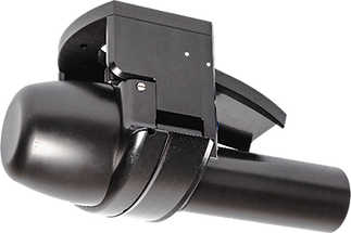
Frequency: 200 to 700 kHz
Opening Angle: 5° to 210°
Number of beams: 512
Resolution: 0.9° x 1.9°
Transmission rate: 0.10 to 60 Hz

Methodology
Acquisition-Processing
Mapping
Survey lines are planned according to water depth to cover the entire area. Depending on the sonar configuration, the swath may span approximately three times the water depth.
Overlap between adjacent passes is defined according to the survey objectives to obtain high-quality data.
CERES sets out these parameters in the technical proposal, which may include a site plan showing the proposed survey lines.

Navigation, acquisition and processing use HYPACK, HYSWEEP and MBMAX. Measurements are corrected for vessel motion using a motion sensor.
Positioning uses our own RTK system or the Orphéon network. Water-level corrections are derived from RTK positioning or tide measurements. Survey speed is adapted to the mission, generally around 3 knots.
Explore our hydrographic survey vessels.

Multibeam surveying provides detailed bathymetric mapping through full coverage and overlap between adjacent passes.
On completion, CERES supplies bathymetric maps together with raw and processed data in XYZ format.

Single-beam surveys
A single-beam echo sounder emits an acoustic pulse through a single beam directed vertically beneath the vessel, providing a depth measurement over a seabed footprint. The diameter of this footprint depends on the water depth and the beam angle.
Equipment
CERES uses a Tritech PA500 single-beam echo sounder, mounted on a pole alongside the vessel. Sensor offsets are documented in the survey report.

Tritech PA500
Frequency: 500 kHz
Acoustic range: 0.3–50 m
Analogue resolution: 0.025% of range (MkI)
Beam angle: 6°
Depth rating: up to 4,000 m, housing-dependent
Digital resolution: 1 mm

Methodology
Data Acquisition and Processing
Mapping
Survey-line spacing and transverse check lines are defined before the mission according to the survey area and measurement objectives.
CERES sets out these parameters in the technical proposal, which may include a site plan showing the proposed survey lines.
Navigation and acquisition use HYPACK Survey, with data processing in SBMAX. Positioning uses our own RTK system or the Orphéon network.
Water-level corrections are derived from RTK positioning or tide measurements. Survey speed is adapted to the mission, generally around 3 knots.
A single-beam echo sounder samples discrete points. Mapping therefore relies on interpolation between measured soundings.
CERES supplies bathymetric maps and raw and processed data in XYZ format.
Explore our technical capabilities and hydrographic projects.

Bathymetry on "Jeune Marine"
By Bertrand Sciboz


